County News
Cressy Bayside

Neighbours still concerned over flood potential of proposed subdivision
Flooding is still at the top of neighbours’ minds for a proposed subdivision overlooking Adolphus Reach. Cressy Bayside Estates is located at 1041 County Road 7 in North Marysburgh, and includes lands of approximately 13.24 hectares running along the southern portion of County Road 7. The proposed subdivision includes eight residential lots ranging in size from 0.8 to 1.7 hectares fronting on Adolphus Reach, which includes a private common element condominium access road. All lots will have private well and septic services.
There is also an existing cemetery—the Turner Hill Pioneer Cemetery—which takes up 1.2 hectares, and is proposed to be conveyed to the municipality, along with a five per cent cash in lieu for parkland.
It is also of note that the files for this project were submitted before the new Official Plan was finalized, so it falls under the 1998 Official Plan.
The subject lands are currently designated Shoreland and Aggregate. The lands that are designated Aggregate are a former sand pit. The sand pits aggregate licence has been surrendered and the sand resource is depleted. The Official Plan Amendment proposes to re-designate the lands to Shoreland to be consistent with the surrounding lands.
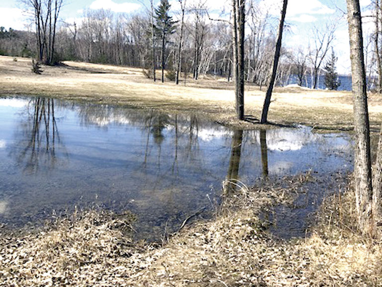
At a public meeting held in September 2021, there were a number of concerns raised regarding flooding and pools of water on the subject lands. Specifically, there was significant flooding on the property in 2017 and 2019. To alleviate these concerns of flooding, the proposed zoning by-law is requiring a 30- metre naturalized buffer from the regulated floodplain with a further six-metre building setback from the 30-metre buffer. There was also concern regarding stormwater and drainage from runoff from the escarpment. The past ponding issues have occurred as the site does not have grading and drainage controls. A stormwater report and grading plan has been submitted which proposes to convey stormwater through roadside ditching along the condominium road to two enhanced grass swales. The swales will convey and treat stormwater runoff towards a level spreader where it will be distributed before discharging in the Bay of Quinte.
Councillor Stewart Bailey was concerned about the impact of the cemetery on ground water. “In my past I had to deal with a cemetery that was contaminating the water in the building next door to it. Is there any possibility of ground contamination from the cemetery in this instance?” he asked.
Ruth Ferguson Althouse, a Planner for the landowner, shared that there was not any worry. “That was one of the technical questions reviewed by the hydrogeoligist. The cemetery dates from the early 1800s and he addressed that in his comments.” She added that there was no traces of formaldehyde present.
A neighbour and 20-year resident, Brian O’Sullivan told council he was never consulted about the building project. “We take exception to this proposal, particularly the rezoning of the property because we have lived here over 20 years and now this new developer has arrived in the last four years and is seeking to change the zoning in a spot we have lived adjacent to for 20 years,” he said. “When I go back to the Official Plan, if the developer is seeking to make changes in the neighbourhood, they are urged to contact and have communication with adjacent property owners. That was never done. Our first clue that something was going on was hearing bulldozers on the property next door.”
O’Sullivan wanted to make it clear he wasn’t trying to railroad the project. “It is our intent to not stop progress, but for it to be done and treated respectfully. How would you feel if you discovered only through your own research that there was an eight-house project going in next door along with a rezoning?” he asked.
Landowner Mark McFaul told council notice had been given. “We sent out flyers in mailboxes. It was during COVID, and it was a public meeting. That is how I was instructed to get those notices out,” he said.
Councillor Brad Nieman asked whether proper notices had been sent out.
Manager of Planning Mike Michaud told council they had. “I know that for the public meeting we did hold in September 2021, we would have followed the same parameters, in terms of getting out notice to those that were within 500 metres. A number of residents did attend and we had a great conversation,” he said.
Talking about past flooding, Councillor Bailey asked whether there was concern of liability for the municipality if the land floods again.
Michaud told the Horseshoe that future phases will include those questions. “If indeed this plan of subdivision does go forward, the next phase of the plan of subdivision is for detailed design. In that design, the developer will have to show that they meet the requirements associated with the 100-year floodplain,” he said. Recently, Quinte Conservation completed new floodplain mapping of the entire County associated with Lake Ontario including the property in question. “That will need to be respected. All buildings and roadways will need to be out of the floodzone,” added Michaud.
“I am disappointed that this made it this far,” said Bailey. “I see that it made it in under the wire and got attached to the 1998 Official Plan. I fully believe that if this were under the new Official Plan, we wouldn’t even be here talking about it right now.”
The draft plan of subdivision, Official Plan ammendment and zoning bylaw amendment were passed.

Comments (0)