County News
Defining shore land
Council balks at imposing new rules and drawing new maps
When the current Official Plan (OP) took effect in 2021, issues around shore land designation proved too thorny and complex to be fully fleshed out in the document. Council punted the matter to a future debate. Years have passed. In the interim, Shire Hall has mostly blocked shore land development—in anticipation of new rules and new maps. But time is running out.
Decisions have to be made. Are lands designated as shore land classified correctly? Do they need the protections and regulations attached to shore land designation in the County’s planning regime? Do the current maps appropriately define shore land? What is shore land?
For a municipality surrounded by water these are big questions—without easy answers. They are often subject to interpretation— eye of the beholder stuff—with potentially large consequences for land owners. Lump in issues pitting collective rights versus individual rights, and you get a recipe for a years-long delay.
The County’s OP currently identifies shore land as an important resource that shall be managed to promote appropriate and sustainable development, focusing on tourism and enhancing public access to the waterfront. It is a definition that is subject to broad interpretation.
To help narrow it down, Shire Hall has begun a comprehensive review of the shore land designation aimed at evaluating the goals, objectives and policies and to consider the location and the extent of the designation. It’s a big project.
Shire Hall’s planning department believes that some shore land should be reclassified as rural or agricultural designations to better reflect the character, features and traditional land use.
Last week Council was asked to an OP amendment to do this.
The Prince Edward County Field Naturalists (PECFN) argue that the shore land designation should be removed altogether—that it conflicts with other safeguards in the OP. PECFN says the designation provides insufficient protection to the environment and “natural heritage system or natural core areas”, according to Amy Bodman of PECFN.
Planning staff countered that the designation needs refinement rather than elimination. Scott Pordham is the County’s Planning Co-ordinator. He said current policy provides insufficient protection on some land and not enough on other shore land. He says a more precise, nuanced and balanced approach is needed to provide clarity.
“We considered public input and reviewed each property on the merits of the request,” said Pordham. “Various changes were made based on the comments where staff felt there was a defendable rational planning argument to justify the changes.”
Council members worked to understand the problem by posing specific examples.
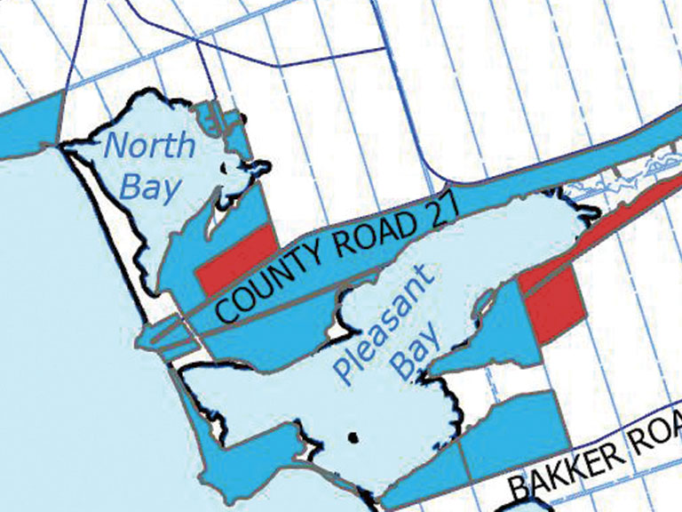
Councillor Brad Nieman asked about one piece of land in Hillier on Pleasant Bay in which one parcel is proposed to be redesignated agricultural while surrounding land would remain shore land.
“The property has soil classes that would normally be prime agricultural,” responded Pordham. “The block of that general area is in a prime agricultural area, so that is why we were looking at it and proposing to put it into an agricultural designation.”
Councillor Phil Prinzen weighed in.
“I find it comical how there is just that parcel,” said the Bloomfield Hallowell council member. “I find it hard to believe, as a farmer who knows a little bit about soil, that the land all through there would not have the same characteristics of soil.”
Prinzen said the proposed redesignations were premature.
“To me, we are changing [land use rules] before we do our zoning by-law review,” said Prinzen. “The cart is in front of the horse. It usually runs better behind the horse. We might be a little premature on this,” he said.
Councillor John Hirsch, a strong advocate for the review, suggested the proposed maps were a good starting point.
“PECFN and other environmental organizations would prefer that the shore land designation go away entirely,” said Hirsch. “This is a good first step. We are looking at removing some of the overlap areas and deciding that they should become either rural or agriculture based on the neighbouring properties,” said Hirsch.
Pordham confirmed that a second phase review would consider additional designation and policy changes.
Other council members found errors and anomalies in the mapping.
We are changing to designations on things we aren’t even going to be owning,” said Wellington councillor Corey Engelsdorfer. “It’s all too big and all too fast.”
Councillor Phil St-Jean was also having difficulty adopting the changes.
“In 2020 I had grave concerns when we were passing our Official Plan with regards to the extreme restrictiveness of Natural Core Areas,” said St-Jean. “We are, in my mind, taking away property owners’ rights. Every step of the way, we need to be extremely careful.”
He agreed that Council needed to see the zoning by-law update to understand the full picture.
Councillor Hirsch tried to reel the discussion back in. He warned that “all hell would break loose” if he and his colleagues didn’t lock down these matters soon.
But Council wasn’t in the mood to be rushed.
Councillor Nieman moved to receive the report but not to approve the proposed changes.
“I want to kill this right now,” he said.
Councillor Roberts supported the motion.
The reality is the nature of this discussion indicates that great events and consequences turn on fine detail,” said Roberts. “These are very consequential decisions of which we don’t have the detail because we don’t have the new and announced Comprehensive Zoning By-law. Let’s get there.”
Nieman’s motion passed, with Councillors Braney, Nieman, Prinzen, Roberts, St-Jean, Pennell and Engelsdorfer in favour. Councillors Hirsch, Mac- Naughton, Maynard, Branderhorst and Mayor Ferguson were opposed.
Comments (0)