County News
Loyalist Heights
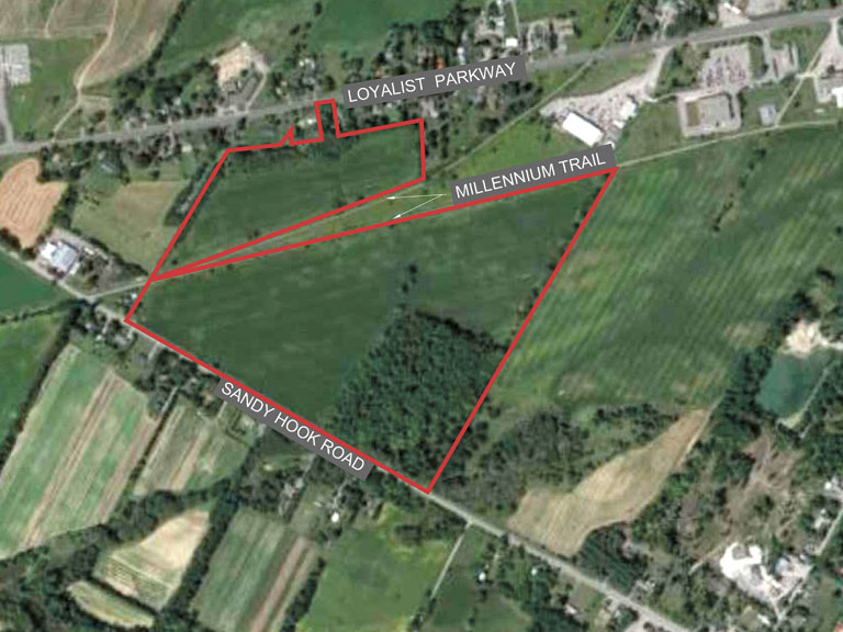
Sandy Hook Road subdivision revealed at public meeting
A proposed residential subdivision for the Sandy Hook Road area on the outskirts of Picton, if approved, will see up to 393 residential dwellings built. A public meeting last Wednesday outlined the details of an application submitted by the applicant, Narisu Huhe, for draft plan of subdivision, an Official Plan amendment, and a zoning by-law amendment for the proposed residential development. More than 40 people tuned into the virtual meeting, including Mayor Steve Ferguson, councillors Kate MacNaughton, John Hirsch, Brad Nieman and Phil Prinzen, along with the applicant and its representatives, and County planning staff. County Planning Coordinator Matt Coffey hosted the meeting, which he noted was a public information meeting for the purpose of hearing from the developer, as well offering an opportunity for the public to ask questions and provide comments. The developer’s representative Matthew McIntosh with Greer Galloway gave a brief overview of the application.
Located at 13437 Loyalist Parkway, the proposed development known as Loyalist Heights is zoned “town residential” and sits on two irregular-shaped parcels of land bisected by the Millennium Trail. The land consists of a total of approximately 25.5 hectares (63 acres): a northern parcel of 5.5 hectares (13.5 acres), and a southern parcel of 19.4 hectares (48 acres). The lands in question were originally designated agricultural until the municipality changed the designation to town residential in 2015. The northern portion is currently zoned Rural 1 (RU1), the southern portion Rural 2 (RU2) and Environmental Protection (EP). The zoning by-law amendment requests re-zoning to Special Urban Residential Type 2 and Special Urban Residential Type 3 (R2x-H and R3x-H) Holding zone, with no change to the Environmental Protection (EP) zone.
The proposed development, with a total of approximately 393 dwelling units, will include 101 single family homes, 56 semi-detached units, 45 townhomes, 156 apartment units, plus a seniors’ village with 30 units (down from 35) to be developed as a condominium. Loyalist Parkway is to the north of the development, Sandy Hook Road to the south, Waring’s Creek is to the east, and the Waring House and the roundabout are to the west. In the southeast corner of the property, a wetland and buffer area associated with Waring’s Creek is designated “environmental protection” and makes up 22 per cent of the total lands. It is anticipated access to the subdivision will be via two access roads off Sandy Hook Road. There will be no connection to Loyalist Parkway from the subdivision.
Target density is in the 17 to 25 range, with estimated high end density at 25 units. “One of the interesting parts of this development is the focus on providing affordable housing,” said McIntosh. There will be 25 units designated as rent-to-own to be administered by the municipality, and 25 units that are sold at or below the CMHC (Canada Mortgage and Housing Corporation) affordability limit. The proposed development includes substantial open space. “The developer has acknowledged that we have no interest in going into and removing or affecting existing woodlot, and the surrounding perimeter trees of the development are intended to remain,” stated McIntosh. “The hope is to keep the buffers and the separations intact and to retain as much of the tree cover as possible.”
The Millennium Trail not only runs through the proposed development, but bisects it and is an element of the development involving new access points. “The eastern crossing we have a road which actually has two sections of the Millennium Trail crossing it,” he said. “There have been conversations about combining those crossings into a single crossing, so that we would end up with the Millennium Trail crossing each of these two roads only once.” He said there are a few benefits to doing that, not least of which is to simplify the vehicle to pedestrian and recreation vehicle interactions.
More than two dozen members of the community presented questions and provided comment, many of whom are close neighbours to the proposed development. Concerns ranged from the number of units backing onto the Millennium Trail, traffic congestion, Millennium Trail crossings, preservation of the tree line, and the environmental impact on wildlife, among others. John Thomson noted the Ontario Farmland Trust indicates every day in Ontario 175 acres of farmland is lost to non-agricultural uses like urban development and aggregate extraction. “This rate of farmland loss is unsustainable and should not be allowed to continue as we all rely on agriculture for the food we eat and for the jobs in our community,” said Thompson. “The farmland in this area chosen for development is among the best in our County. Why have you chosen this rather than the non-arable land on Picton Heights?” he asked.
Several board members with the Waring’s Creek Improvement Association expressed concern about the proposed development and asked if the significance of the tree stand had been understood. “It’s not just trees, it is trees sitting in a wetland that is hundreds of springs, it is a spring-fed woods,” stated Joanne Tammel. McIntosh noted again the tree stand is currently zoned as environmentally sensitive. “We are doing our best to recognize and work with that and locate the elements of the development around it accordingly,” he said. “This is not just a stand of trees, this is an important stand of trees in a very important wetland that basically feeds an entire seven-kilometre freshwater creek,” added Tammel.
Cheryl O’Brien asked if the County would be amenable to having a tree cutting bylaw put in the area. “There is a requirement for a tree preservation plan in our subdivision, but no tree cutting bylaw exists at this time in the County,” said McIntosh. Ray Essiambre, planner for the development, spoke to the trees and Waring’s Creek. “The proponents are well aware of the concerns and the proposal is to have all the woodlot, the open space and the pond dedicated to the County under public ownership,” said Essiambre. He confirmed concern over the woodlot and Waring’s Creek was understood. “It is going to remain in its natural state, so it’s protected and expanded.”
Margaret Berwick whose family has farmed and worked on the land for four generations said the subdivision will permanently destroy some precious and prime agricultural lands. “It will potentially harm the fragile Waring’s Creek watershed and offer very little much-needed affordable housing,” said Berwick. “Just because this land has been zoned for development and you can develop it, does it mean it has to be and is it the right thing to do? questioned Bob Rogers, referring to the site as significant class 1 farmland.
The public meeting was for information purposes only and no decisions were made. The public will have one final opportunity to provide comments on the proposed development in the form of a statutory public meeting before the application goes to council for decision. Documentation pertaining to this application can be found on the County’s website. Questions can be directed to Matt Coffey with the planning department at mcoffey@pecounty.on.ca.
Comments (0)