County News
Rising
County won’t declare emergency amidst rising water levels
On Monday morning, Mayor Steve Ferguson called a special media event to update the public on water levels in Prince Edward County. Ferguson noted that the municipality’s primary concern has been and will remain public safety.

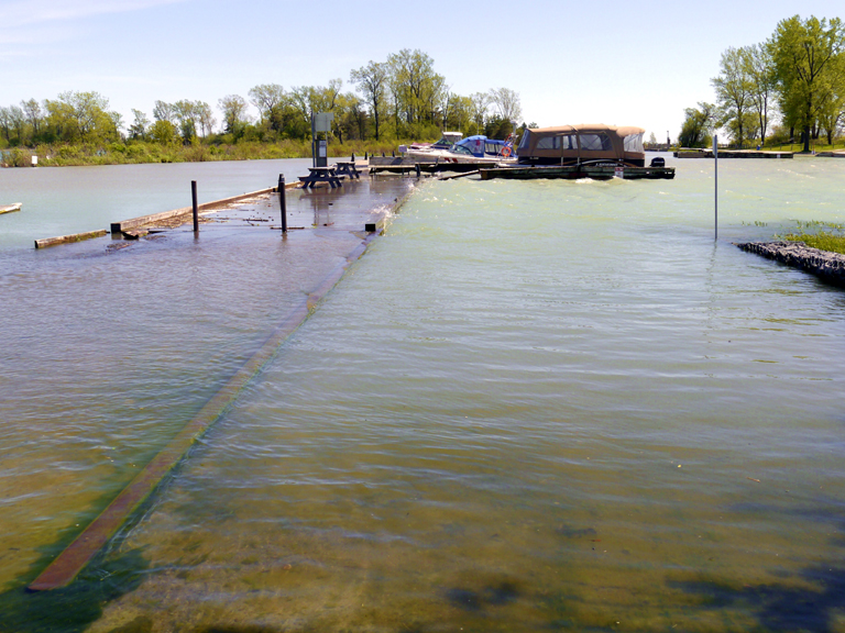
Record-high lake levels impede access to the boat launch and docks at Wellington Harbour as water levels continues to rise.
Since Wednesday, April 24, the County’s Municipal Control Group—whose purpose is to deal with situations that pose a threat to the well-being of the municipality—has met 10 times to review flood forecasts and respond to flood conditions. “Based on the lessons learned in 2017, we expanded access to sand and sandbags,” said Ferguson. “Currently we have 12 self-serve sand and sandbagging depots throughout the County, and we are well stocked with additional sandbags and sand in preparation for the rising water levels.”
Ferguson has been fielding questions on why the County hasn’t declared an emergency, as it did in 2017 when water levels reached record levels. “After careful consideration and discussion, it was decided not to declare an emergency at this time. One of the major reasons for declaring is to set aside certain policies and procedures to expedite our responses. In 2017, declaring an emergency was deemed necessary because the municipality had never experienced water levels as high as they rose that year. Furthermore, those water levels in 2017 rose much more quickly than they have this year,” said Ferguson. “Residents can access support through the Red Cross or file an insurance claim without the municipality declaring an emergency,” added Ferguson.
Acting CAO Robert McAuley also noted that there is no financial advantage to declaring an emergency, and it also has a much more detrimental impact. “One of the things we did learn in 2017, when we did declare, we had a markedly steep drop in our own business. If we are going into our primary tourist season and we declare an emergency, the message that sends is not a favourable one for the County,” said McAuley. Ferguson explained that business dropped significantly in 2017, which had a trickle-down effect to things such as employment.
Christine Phillibert of Quinte Conservation explained that Lake Ontario has reached 75.90 m (249.02 ft), exceeding the record peak of 75.88 m (248.95 ft) set in 2017, and will continue rising gradually over the next several days, but is expected to reach this year’s peak within one to three weeks. “The current forecast for Lake Ontario are another rise of three to nine centimetres over the next one to three weeks. What we are seeing is the rate of rise has decreased over the past week,” said Phillibert.

Wellington’s Beach Street was closed to traffic Monday as the lake encroached upon the road and surrounding properties.
Phillibert went on to say that high water levels are indicative of a number of factors. “Lake Erie is at a record high for this time of year. Lake Erie is sitting at about 10 centimetres above the current record for this time of year and all of the water that flows over Niagara Falls is completely uncontrolled. The Ottawa River reached record highs this year, and that flows into the lower St. Lawrence River, which is also at record high for this time of year,” said Phillibert.
According to the International Lake Ontario – St. Lawrence River Board, whose main duty is to ensure that outflows from Lake Ontario meet the requirements of the International Joint Commission’s 2016 Order implementing Plan 2014, outflows from Lake Ontario continue to be increased as rapidly as conditions allow. Ottawa River flows have been declining slowly, but remain very high. The Ottawa River discharges into the St. Lawrence River and combines with the water released from Lake Ontario near Montreal. This is causing high levels in the lower St. Lawrence River, where many adjacent areas have been flooded since April.
The 2016 Order provides criteria for managing flows through the Lake Ontario – St. Lawrence River system, which are incorporated in Plan 2014. Allowing for more natural variations of water levels, the plan aims to foster the conditions needed to restore Lake Ontario and upper St. Lawrence River coastal wetlands and improve habitat for fish and wildlife. The plan will also frequently extend the Lake Ontario recreational boating season in the fall, better maintain system-wide levels for navigation and allow for a modest increase in hydropower production compared to the previous plan, Plan 1958D. The Moses-Saunders Power Dam, which straddles the border between the United States and Canada in Cornwall, supplies water to two adjacent power stations, as well as regulates outlflow to the St. Lawrence River and affords passage for the navigation of large vessels.
The County has closed six boat launches, but is working to keep roads that are affected by the flooding open for public use. Winns Drive, which connects to Sheba’s Island, and Wesley Acres Road in Bloomfield, are two of the most impacted roadways. Straw bales will be placed along the road to try to mitigate flooding, as there is no alternative route for residents to access their homes.
Beach Street in Wellington has also been closed to all but local traffic.
Comments (0)